![](/images/other/stat-length.png)
![Excursión Senderismo Le Reposoir - La Pointe Blanche, 2438 m - Le Grand Bornand - Photo](https://media.geolcdn.com/t/1900/400/ext.pjpeg?maxdim=2&url=https%3A%2F%2Fservices.sitytrail.com%2FGeolivesWS%2FDownloadMedia.ashx%3FTrailID%3D172479%26Media%3D13835_1.jpg)
La Pointe Blanche, 2438 m - Le Grand Bornand
tracegps
Usuario
![Longitud](/images/other/stat-length.png)
![Altitud máxima](https://static1.geolcdn.com/siteimages/upload/files/1508320355ic_sort_altitude_max_24dp.png)
![Desnivel positivo](https://static1.geolcdn.com/siteimages/upload/files/1508320355ic_sort_den_pos_24dp.png)
![Km-Effort](/images/other/stat-length.png)
![Altitud mínima](https://static1.geolcdn.com/siteimages/upload/files/1508320355ic_sort_altitude_min_24dp.png)
![Desnivel negativo](https://static1.geolcdn.com/siteimages/upload/files/1508320355ic_sort_den_neg_24dp.png)
![Boucle](https://static1.geolcdn.com/siteimages/upload/files/16400158638029165_repeat_loop_refresh_sync_direction_icon.png)
![Senderismo](https://static1.geolcdn.com/sitytour/trail-icons/101.png)
6h00
Dificultad : Muy difícil
![Escanee este código QR para abrir la excursión en la aplicación SityTrail](https://capi.geolives.com/qq0zvz2zws4bq2lad0pu/sitytour/trails/172479/qr.png?size=200)
Aplicación GPS de excursión GRATIS
A propósito
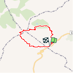
Ruta Senderismo de 5,7 km a descubrir en Auvergne-Rhône-Alpes, Alta Saboya, Le Reposoir. Esta ruta ha sido propuesta por tracegps.
Descripción
L'ascension sauvage de la Pointe Blanche est une course magnifique réservée cependant, aux randonneurs confirmés. En partant du Col de la Colombière, une combe encaissée entre les falaises des arêtes du Pic de Jallouvre et de la Pointe Blanche débouche au Col du Rasoir. Après une traversée, l'escalade d'une courte cheminée donne accès aux dernières pentes qui défendent encore le sommet. La descente commence dans la face Sud pour trouver à droite la variante difficile du Passage Pellier et prendre pied dans la combe du Col de Balafrasse à proximité du Lac de Peyre pour rejoindre le Col de la Colombière par un sentier facile et fréquenté. Description complète sur sentier-nature.com : >La Pointe Blanche, 2438 m Avertissement [Franchissement 3/3 ; Exposition 3/3]. Certains passages de cet itinéraire de montagne sont escarpés et/ou très exposés, il est déconseillé aux enfants non accompagnés et aux personnes sujettes au vertige. Pour votre sécurité, nous vous invitons à respecter les règles suivantes : être bien chaussé, ne pas s'engager par mauvais temps, ne pas s'écarter de l'itinéraire ni des sentiers. Pour assurer les moins expérimentés, une corde d'une vingtaine de mètres peut être utile. Il apparaît souhaitable de réaliser cette course par temps sec.
Localización
Comentarios
Excursiones cerca
![Excursión Senderismo Glières-Val-de-Borne - BARGY: ROCHERS DE LESCHAUX AU DEPART DE CENISE - Photo](https://media.geolcdn.com/t/375/260/5ac05f8e-3735-47a8-a18c-c0c850908ba7.jpg&format=jpg&maxdim=2)
![Senderismo Senderismo](https://static1.geolcdn.com/sitytour/trail-icons/101.png)
Senderismo
![](/images/other/stat-length.png)
![](https://static1.geolcdn.com/siteimages/upload/files/16400158638029165_repeat_loop_refresh_sync_direction_icon.png)
![Excursión Senderismo Le Grand-Bornand - Lac de Lessy depuis le Chinaillon - Photo](https://media.geolcdn.com/t/375/260/ext.jpg?maxdim=2&url=https%3A%2F%2Fservices.sitytrail.com%2FGeolivesWS%2FDownloadMedia.ashx%3FTrailID%3D224812%26Media%3Dfix__20130925155702.jpg)
![Senderismo Senderismo](https://static1.geolcdn.com/sitytour/trail-icons/101.png)
Senderismo
![](/images/other/stat-length.png)
![](https://static1.geolcdn.com/siteimages/upload/files/16400158638029165_repeat_loop_refresh_sync_direction_icon.png)
![Excursión Senderismo Le Reposoir - Le Petit Bargy 2098 m, depuis Malatrait - Photo](https://media.geolcdn.com/t/375/260/ext.jpg?maxdim=2&url=https%3A%2F%2Fservices.sitytrail.com%2FGeolivesWS%2FDownloadMedia.ashx%3FTrailID%3D215073%26Media%3D15647_1.jpg)
![Senderismo Senderismo](https://static1.geolcdn.com/sitytour/trail-icons/101.png)
Senderismo
![](/images/other/stat-length.png)
![](https://static1.geolcdn.com/siteimages/upload/files/16400158638029165_repeat_loop_refresh_sync_direction_icon.png)
![Excursión Senderismo Mont-Saxonnex - Les Rochers de Leschaux, 1936m - Mont Saxonex - Photo](https://media.geolcdn.com/t/375/260/ext.jpg?maxdim=2&url=https%3A%2F%2Fservices.sitytrail.com%2FGeolivesWS%2FDownloadMedia.ashx%3FTrailID%3D172447%26Media%3D13800_1.jpg)
![Senderismo Senderismo](https://static1.geolcdn.com/sitytour/trail-icons/101.png)
Senderismo
![](/images/other/stat-length.png)
![](https://static1.geolcdn.com/siteimages/upload/files/16400158638029165_repeat_loop_refresh_sync_direction_icon.png)
![Excursión Esquí de fondo Le Grand-Bornand - Col de Balafrasse et tout de la pointe Est du midi - Photo](https://media.geolcdn.com/t/375/260/43833717-d102-4f65-80da-59cdd532a1e7.jpg&format=jpg&maxdim=2)
![Esquí de fondo Esquí de fondo](https://static1.geolcdn.com/sitytour/trail-icons/503.png)
Esquí de fondo
![](/images/other/stat-length.png)
![](https://static1.geolcdn.com/siteimages/upload/files/16400158638029165_repeat_loop_refresh_sync_direction_icon.png)
![Excursión Esquí de fondo Glières-Val-de-Borne - Tour du Jallouvre par le lac de Lessy - Photo](https://media.geolcdn.com/t/375/260/1d705345-d276-40a8-b673-92ff954efff5.jpg&format=jpg&maxdim=2)
![Esquí de fondo Esquí de fondo](https://static1.geolcdn.com/sitytour/trail-icons/503.png)
Esquí de fondo
![](/images/other/stat-length.png)
![](https://static1.geolcdn.com/siteimages/upload/files/16400158638029165_repeat_loop_refresh_sync_direction_icon.png)
![Excursión Esquí de fondo Glières-Val-de-Borne - col du rasoir combe NW ET Sud - Photo](https://media.geolcdn.com/t/375/260/c51ae7d8-65f2-4ba4-b4a6-8cbff7bf96a0.jpg&format=jpg&maxdim=2)
![Esquí de fondo Esquí de fondo](https://static1.geolcdn.com/sitytour/trail-icons/503.png)
Esquí de fondo
![](/images/other/stat-length.png)
![](https://static1.geolcdn.com/siteimages/upload/files/16400158638029165_repeat_loop_refresh_sync_direction_icon.png)
![Excursión Senderismo Le Reposoir - au dessus de la grotte de motarquis - Photo](https://media.geolcdn.com/t/375/260/6633e4c3-051b-48bd-b57d-3a22c34b0388.jpg&format=jpg&maxdim=2)
![Senderismo Senderismo](https://static1.geolcdn.com/sitytour/trail-icons/101.png)
Senderismo
![](/images/other/stat-length.png)
![](https://static1.geolcdn.com/siteimages/upload/files/16400158638029165_repeat_loop_refresh_sync_direction_icon.png)
![Excursión Senderismo Le Reposoir - pointe blanche par l'arête Est - Photo](https://media.geolcdn.com/t/375/260/49880efe-479d-4396-9a1d-07cba2b79941.jpg&format=jpg&maxdim=2)
![Senderismo Senderismo](https://static1.geolcdn.com/sitytour/trail-icons/101.png)
Senderismo
![](/images/other/stat-length.png)
![](https://static1.geolcdn.com/siteimages/upload/files/16400158638029165_repeat_loop_refresh_sync_direction_icon.png)